HAWAII LAND SURVEYING
FOR PROFESSIONALS
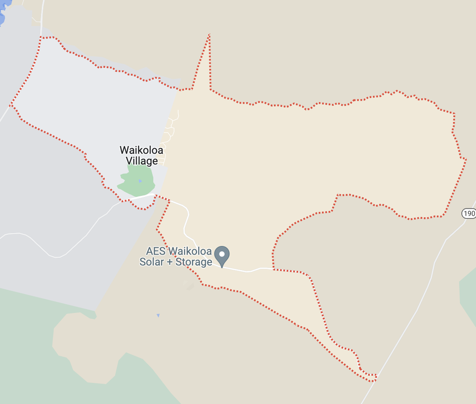
Hawaii Land Surveying - Civil Engineers, Architects, Designers, and Custom Home Builders, need a topography map or construction stake out before working with a new client? Thomas Pattison is a licensed surveyor, LPLS #10743, in the state of Hawaii with over 35 years of professional land surveying experience. In addition to topography maps and constructions stake outs, Pattison Land Surveying also offers as-built surveys, certificates for pad height elevation, certificates for roof height elevations, FEMA certification, shoreline surveys, aerial LiDAR surveys, and more. Pattison Land Surveying offers professional and prompt service. Thomas Pattison has been Surveying the Big Island since 2003.
LAND SURVEYING SERVICES
FOR PROFESSIONALS
|
|
|
ATTENTION: We are moving our website to another domain. Please request your quotes on our new domain by going to pattisonsurveying.com
|
DEFINITION OF SURVEYS
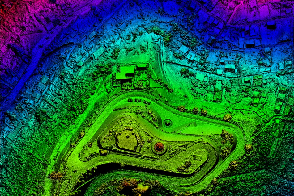
Hover and click the survey name or the (+) icon to view the survey definition. This staking is for properties in escrow. We find and verify all boundary or property corner markers. Replace any disturbed or missing boundary or property corner markers. A verification statement in the form of a written certificate of the property, signed by the licensed surveyor, will be provided. This is a full property survey for a property that is in escrow. We find and verify all boundary or property corner marks. Reset or replace any missing boundary or property corners. Provide a computer or CAD map in PDF format of the existing conditions upon the property showing any found boundary or property line encroachments, and any County zoning setback violations. Provide a written report explaining the survey map, any boundary or property line encroachments, and any county zoning setback violations. This survey is typically required by a title company or a bank issuing a loan. We find and verify all boundary or property corner markers. Reset any missing boundary or property corner markers. Provide an “As-Built” survey map in {.dwg} format of existing conditions upon the lot showing any found encroachments and/or county setback violations. Survey map to show all As-Built conditions on the ground and adhere to ALTA standards and requirements as per the lender and/or title or escrow company. *Require latest title report to complete this survey* This survey is performed after construction of a building or structure is complete and is to ensure the building or structure is built according to the building plans. HOA associations commonly ask for this survey. We find and verify all boundary or property corner markers. Reset any missing boundary or property corner markers. Provide an “As-Built computer-generated map of existing conditions showing all improvements, utilities, and easements. Show boundary or property lines on map. This is a more detailed topographical map, typically ordered by engineers to determine the features of the land’s surface. We find and verify all boundary or property corner marks and reset any missing corners. Provide a CAD or computer-generated map in electronic {.dwg} format of said lot, including contour lines and elevations generated by AutoCAD and MicroStation compatible active X, Y, Z aerial LiDAR data points obtained via a drone mounted aerial terrestrial LiDAR system. Contour lines to contain elevation data as P-Lines or triangulated surface. Provide a PDF of said map. The topographic map shall show any boundary or property line encroachments plus any County setback violations. *Contours are in 1ft or 2ft increments* This is for fence installation. We physically mark points along the boundary or property line as specified by the client. *This is field work only. No map or report will be provided* This is for staking the corners of the lot only. We find and verify all boundary or property corner markers. Replace any disturbed or missing boundary or property corner markers. *This is field work only. No map or report is provided* This is a full property survey that is not in escrow. We find and verify all boundary or property corner marks. Reset or replace any missing boundary or property corners. Provide a computer or CAD map in PDF format of the existing conditions upon the property showing any found boundary or property line encroachments, and any County zoning code setback violations. Provide a written report explaining the survey map, any boundary or property line encroachments, and any County zoning code setback violations. *Please choose this option if you are having a boundary line or encroachment dispute with a neighbor* This is to consolidate multiple lots into one lot or adjust a boundary line. We provide a computer-generated final subdivision map of said subdivision as per County specs. Physically mark new boundary or property corners on the ground. Provide a written certificate of said parcel, as per client’s instructions, signed by the licensed land surveyor, for the client to submit to the County of Hawaii for tentative approval. This is for residential homes or commercial buildings. We stake out construction points on the ground as per contractor or client’s request. The CAD files are required with the points needing to be marked in red or magenta dots. *This is field work only. No maps or reports will be provided* Please note that we do not do offsets for construction stake outs* This is required for flood insurance. We locate existing buildings and tie into a known benchmark elevation to calculate building height. We provide a flood plain certification with a State of Hawaii licensed land surveyor’s stamp. This is generally for new or old properties that have no legal descriptions or for easements. We draft a metes and bounds legal description of the subject property for the TMK(s) provided. This is to ensure building heights are in conjunction with HOA associations requirements and will not block other homeowner’s views. We locate existing buildings and tie into a known benchmark elevation to calculate building height. Provide a pad height elevation certificate signed by the State of Hawaii licensed surveyor. A property easement is a right to cross or otherwise use someone else’s land for a specified purpose such as road access. We provide a computer or CAD map in PDF format of the property easement and draft a metes and bounds legal description of the easement. The property easement map and legal description will be signed by the State of Hawaii licensed surveyor. This is to ensure building heights are in conjunction with HOA associations requirements and will not block other homeowner’s views. We locate existing buildings and tie into a known benchmark elevation to calculate building height. Provide a roof height elevation certificate with a State of Hawaii licensed surveyor stamp. This survey determines the shoreline boundary and location of the setback for building. We perform an on the ground professional land survey of the shoreline. Physically mark the new boundary or property corners along the shoreline boundary. Provide a computer-generated certified shoreline survey map, signed by the licensed surveyor, as per DLNR requirements for client to submit to the county of Hawaii for tentative approval. This is to divide one parcel into two or more parcels. We subdivide property per client’s instructions and include the following: preliminary subdivision map, construction staking of subdivision lots and roads, all subdivision easement legal descriptions, subdivision staking certificate, final subdivision map, and individual legal descriptions of each subdivision lot. Provide a computer-generated preliminary subdivision map, signed by the licensed land surveyor, for the client to submit to the County of Hawaii for tentative approval. *This process takes 3-6 months *Please provide a map with the new subdivision lines drawn on with a bright color* This is to determine the features of the land’s surface such as its elevations. Generally, this is ordered prior to building new residential homes or commercial buildings, to be used for drainage studies, and engineering. We find and verify all boundary or property corner marks and reset any missing corners. Provide both a CAD or computer-generated map in electronic {.dwg} format of said lot, including contour lines and elevations generated by a conventional GPS system, drone LiDAR system, or helicopter LiDAR system. Contour lines to contain elevation data as P-lines or triangulated surface, and a PDF of said map. The topographic map shall show any boundary or property line encroachments, and any County setback violations. Provide a K2 report which addresses any boundary or property line encroachments, and any County setback violations *Contours are in 1ft or 2ft increments* This is to determine the features of the land’s surface such as its elevations. Generally, this is ordered prior to building new residential homes or commercial buildings, to be used for drainage studies, and engineering. We find and verify all boundary or property corner marks and reset any missing corners. Provide both a CAD or computer-generated map in electronic {.dwg} format of said lot, including contour lines and elevations generated by a conventional GPS system, drone LiDAR system, or helicopter LiDAR system. Contour lines to contain elevation data as P-lines or triangulated surface, and a PDF of said map. The topographic map shall show any boundary or property line encroachments, and any County setback violations. *Contours are in 1ft or 2ft increments* This is to determine the features of the land’s surface such as its elevations. Generally, this is ordered prior to building new residential homes or commercial buildings, to be used for drainage studies, and engineering. The shoreline survey determines the shoreline boundary and location of the setback for building. We find and verify all boundary or property corner marks and reset any missing corners. Provide both a CAD or computer-generated map in electronic {.dwg} format of said lot, including contour lines and elevations generated by a conventional GPS system, drone LiDAR system, or helicopter LiDAR system. Contour lines to contain elevation data as P-lines or triangulated surface, and a PDF of said map. The topographic map shall show any boundary or property line encroachments, and any County setback violations. Perform an on the ground professional land survey of the shoreline. Physically mark the new boundary or property corners along the shoreline boundary. Provide a computer-generated certified shoreline survey map, signed by the licensed surveyor, as per DLNR requirements for client to submit to the county of Hawaii for tentative approval. *Contours are in 1ft or 2ft increments* |
QUOTE FOR CLIENTIf you are having issues in submitting the form and have encountered an error, please take a screenshot of the error displayed and email it to [email protected]
|